
A Guide to 25 Waterfalls from Canal to Coast and points between
When Craig Romano agreed to share with us a few of his favorite waterfalls in the Pacific Coastal region of Washington, we were frankly thrilled. If you’re looking for straight details on Northwest hikes and wilderness destinations — and fun facts - Craig is the guy to call.
Craig has written more than 20 hiking guidebooks including Day Hiking Olympic Peninsula 2nd Edition which includes details for popular and little known hikes across the Peninsula. An avid hiker, runner, paddler, and cyclist, Craig is currently working on Urban Trails Vancouver USA (2020); Backpacking Washington 2nd Edition (2021); and Day Hiking Central Cascades 2nd Edition (2022). He is also a featured columnist for the Fjord and Explore Hood Canal.

Enchanted Valley | Craig Romano photo
Why we are so keen about our falls?
As storms from the Pacific Ocean move across the peninsula, they crash into the Olympics and are forced to release moisture in the impact. Consequentially, the clouds release massive amounts of moisture (up to 170 inches annually) in the coastal side of the range – creating the “rain shadow effect.”
The massive rainfall has given life blood to the hanging mosses of the perpetually wet Northwest rainforests – Hoh and Quinault. On top the Olympic Mountains this moisture lands as snow frosting the peaks with as much as 35 feet each year.
Each spring the snow melts and creates icy run-off. Mix in a little more rainfall and the result is a spectacular waterfalls ring envelops the base of Olympic range.
Pacific coastal waterfalls are gorgeous year round but tend to be most spectacular in early spring or during the autumn rainy season.
Let’s go Chasing Waterfalls
1. Tumwater Falls
Olympia Metro | Located minutes from Olympia, Tumwater Falls is an iconic landmark near the state capital. These thundering multi-tiered showy falls along the Deschutes River are located within a 15-acre park created on land donated by the Olympia Brewing Company. Meander along manicured paths and saunter over foot bridges and under historic road bridges taking in a little history along with the sensational scenery.
At the base of the upper falls admire a replica of the famous bridge that once appeared on the labels of Olympia beer spanning the river above the lower falls. Walk trails along the gorge between the falls and admire deep pools, eddies and jumbled boulders. Take time to read the informative panels on Tumwater—Washington’s oldest permanent non-Native settlement on Puget Sound. Let’s Go!
2. Kennedy Creek Falls
Kamilche, South of Shelton | From its origin at Summit Lake in the Black Hills, Kennedy Creek flows just shy of 10 miles to Oyster Bay tumbling over a two-tiered waterfall along the way. Reaching these pretty falls involves a half day hike on a closed-to-vehicles logging road through patches of cuts and mature standing timber. Start walking across a recent cut. In about a mile reach a grove of mature timber and the Kennedy Creek Salmon Trail which opens in the fall for salmon viewing and field trips. Keep walking on the main road avoiding diverting roads. The route leaves state land for private timberland and rolls along. Take in decent views of the surrounding foothills. At 2.8 miles (just before crossing a creek) follow an obvious but unmarked trail to the right. This path can be muddy and slick during periods of heavy rainfall. The trail descends to a grove of big cedars, firs and yews—and the falls. Here Kennedy Creek tumbles over an ancient basalt flow. The upper falls are small but quite pretty. The lower falls are difficult to see as they tumble into a narrow chasm of columnar basalt. Let’s Go!
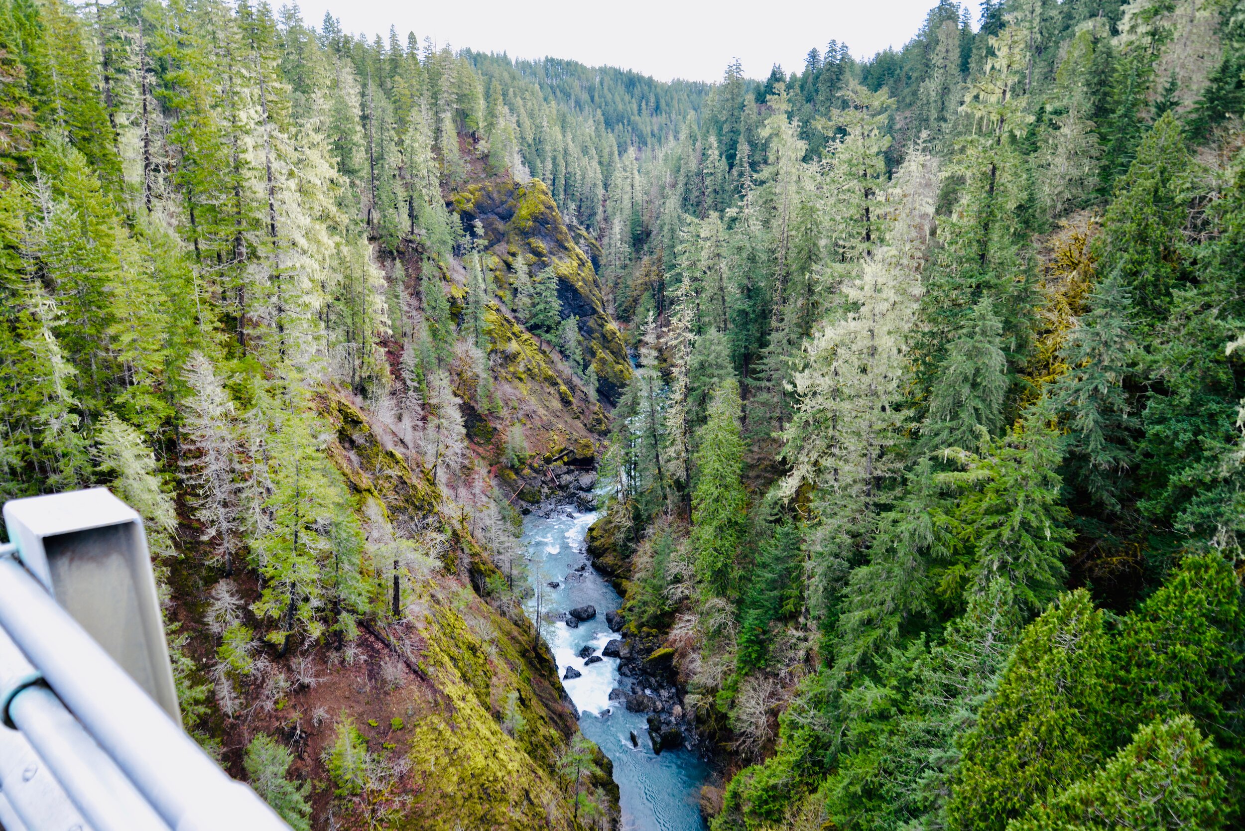
3. Vincent Creek Falls
South Hood Canal, Skokomish Valley | While Vincent Creek Falls are quite stunning crashing 250 feet into the South Fork Skokomish River in a deep narrow canyon; the High Steel Bridge which allows for their viewing is even more spectacular. The 685-foot long bridge spans 375 feet above the canyon. Walk across the bridge but use caution along its north side where the guardrail is only 3 feet tall. The arched truss steel bridge was built in 1929 originally for a logging railroad. In 1950 it was converted for road use. It is the 14th highest bridge in the country. Your heart is sure to pound as you walk upon its airy span. Eventually Vincent Creek Falls comes into view. Through a series of falls, Vincent Creek drops 250 feet down a canyon wall into the roaring South Fork Skokomish River. Walk all the way across the bridge if you plan on capturing the falls in their entirety in a photo. Let’s Go!

Big Creek | Craig Romano Photo
4. Big Creek Cascades
Lake Cushman Area, Hood Canal | Amble on a circuitous route in the Big Creek drainage within the shadows of Mount Ellinor; and delight in a series of small tumbling cascades. This wonderful loop utilizes old logging roads, new trails and a series of beautifully built bridges. It was constructed by an all-volunteer crew that continues to improve and maintain this excellent family and dog-friendly loop. Starting from the Big Creek Campground, follow the Upper Big Creek Loop Trail to Big Creek and the first of several sturdy bridges along the way. After a short climb you’ll reach the Creek Confluence Trail which drops to the confluence of the tumbling Big and North Branch Creeks. The main loop continues to cross North Branch Creek on a good bridge. Just beyond it crosses Big Creek on a new bridge above a gorgeous cascade. The loop then descends skirting big boulders and passing good views of roaring Big Creek. It crosses a couple more cascading creeks before traversing attractive forest and returning to the campground. Let’s Go!
5. Staircase Rapids
Lake Cushman Area, Hood Canal — Currently Closed until mid-September
This loop involves a section of an historic route across the Olympic Mountains to a suspension bridge spanning the North Fork Skokomish River near a series of thundering rapids. Cross the North Fork Skokomish on a solid bridge and follow a trail that was once part of the original O’Neil Mule Trail. In 1890 Lieutenant Joseph O’Neil accompanied by a group of scientists led an Army expedition across the Olympic Peninsula. Among his party’s many findings was a realization that this wild area deserved to be protected as a national park. March up alongside the roiling river, passing big boulders and a series of roaring rapids. The rapids’ name come from a cedar staircase O’Neil built over a rocky bluff to get past them. Follow the bellowing river from one mesmerizing spot to another before reaching a sturdy suspension bridge spanning the wild waterway. Cross the river and complete this delightful loop by now heading downriver following the North Fork Skokomish River Trail back to the Ranger Station. Let’s Go!
Hamma Hamma | George Stenberg photo
6. Hamma Hamma Falls
Hamma Hamma River Valley, Hood Canal | Talk about a bridge over troubled waters. From the Mildred Lakes Trailhead walk across the high concrete bridge at the road’s end. You no doubt heard the roar of the falls when you drove across it. Now peer over the bridge and witness the cataracts responsible for the racket.
Directly below, the Hamma Hamma River careens through a tight rocky chasm. These impressive falls are two-tiered crashing more than 80 vertical feet. The road spans directly above the upper and smaller of the falls. The overhead view is pretty decent, but the lower and larger falls are more difficult to fully see. A very rudimentary path leads along cliff edges for better viewing, but it’s slick, exposed and treacherous.It’s best to experience the falls from the safety of the bridge. During periods of high water flow you’ll get the added bonus of feeling the falls too thanks to a rising mist. On the drive back look for a couple of pull-offs providing views of secondary falls along the Hamma Hamma, Let’s Go!
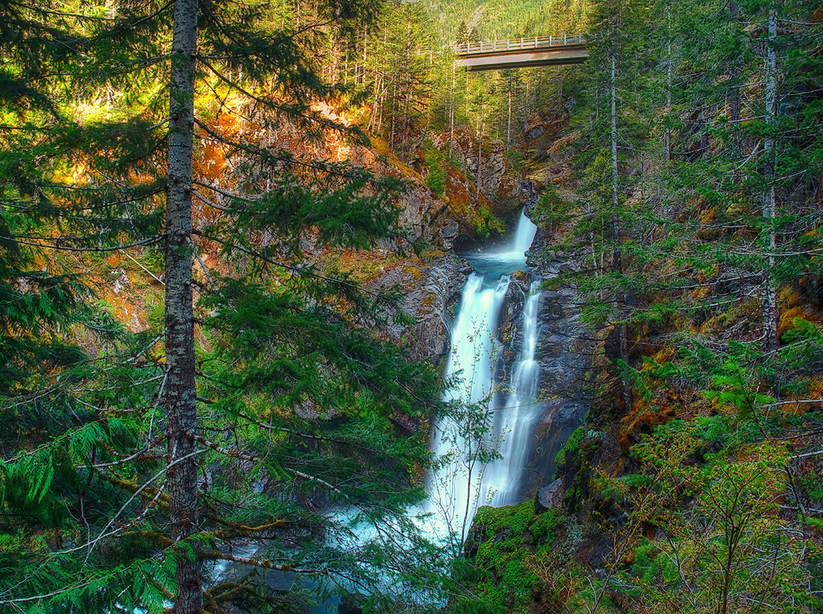
7. Murhut Falls
Duckabush River Valley, Hood Canal | Hidden in a lush narrow ravine and once accessed by a treacherous path, Murhut Falls were long unknown to many in the outside world. But now a well-built trail allows hikers of all ages and abilities to admire this beautiful 130-foot two-tiered waterfall. The trail starts by following an old well-graded logging road. It was past logging in this area that led to the discovery of these falls. The old road ends after a short climb of about 250 feet to a low ridge. The trail then continues on a good single track slightly descending into a damp, dark, cedar-lined ravine. As you work your way toward the falls, its roar will signal you’re getting closer. Reach the trail’s end and behold the impressive falls crashing before you. The upper falls drops more than 100 feet while the lower one crashes about 30 feet. Blossoming Pacific rhododendrons lining the trail in May and June make the hike even more delightful. Let’s Go!
Rocky Brook Falls
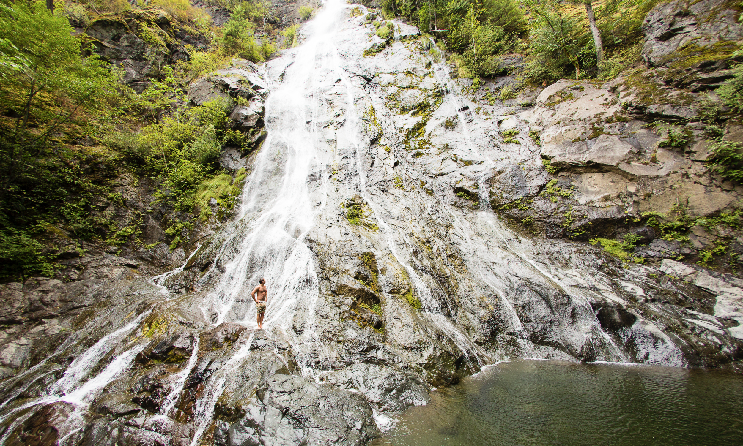
8. Rocky Brook Falls
Dosewallips River Valley, Hood Canal | One of the tallest waterfalls on the Peninsula, Rocky Brook Falls is also among the prettiest. Follow the trail past a small hydroelectric generating building and come to the base of the stunning towering falls fanning over ledges into a large splash pool surrounded by boulders. This classic horsetail waterfall crashes more than 200 feet from a small hanging valley above. While a penstock diverts water from the brook for electricity production, the flow over the falls is almost always pretty strong. Like all waterfalls, these too are especially impressive during periods of heavy rainfall. On warm summer days the falls become a popular destination for folks seeking some heat relief. And while many waterways east of the Mississippi River are called brooks, creek is the preferred name in the west. There are only a few waterways on the Peninsula called brooks, and they were more than likely named by someone who hailed from back east. Let’s Go!
9. Dosewallips Falls
Dosewallips River Valley, Hood Canal | This spectacular waterfall used to be easily reached by vehicle. But the upper Dosewallips Road has been closed to vehicles since 2002 after winter storms created a huge washout that has yet to be repaired. Now to reach this waterfall you must hike or mountain bike the closed road. Walk past the road barrier and immediately come to the washout and a bypass trail. Steeply climb on the riverbank above the slide. Then descend back to the road and walk along the churning river. The road then pulls away from the river, passes a campground and climbs. The river now far below in a canyon is out of sight, but not out of sound. Pass beneath ledges and cross cascading Bull Elk Creek on a bridge. At 3.9 miles in a recent burn zone enter Olympic National Park. Cross tumbling Constance Creek on a bridge and continue climbing passing a big overhanging boulder. Then descend and skirt beneath a big ledge coming to the base of dramatic 100-foot plus Dosewallips Falls. Admire the raging cascade’s hydrological force—it’s mesmerizing. Let’s Go!
10. Fallsview Falls
Big Quilcene River Valley | As far as cascades go, Fallsview Falls lacks the “Wow factor.” However the canyon these falls tumble into is pretty impressive. And if you plan your visit for late spring, blossoming rhododendrons line the trail and frame the view with brilliant pinks and purples. The trail to the falls is short, easy and ADA accessible. Follow the 0.2 mile loop to a fenced promontory above a tight canyon embracing the Big Quilcene River. Gaze straight down to the roiling river. Then cast your glance directly across the canyon to an unnamed creek cascading 100 feet into it. By late summer it just trickles—but during the rainy season the falls put on a little show. If you want to stretch your legs some more afterward, you can follow a trail into the little canyon and hike along the frothing river. Let’s Go!

And 15 more…
For a day trip, weekend, or a month-long adventure – the Olympic Peninsula is a fantastic place to get away and enjoy nature – and waterfalls! It’s not just 1000’s of waterfalls, there are countless lakes, rivers, streams and trails to suit every ability level. Embraced by the Pacific Ocean on the west, the Strait of Juan de Fuca on the north, and the Hood Canal on the east, it is famed for being home to Olympic National Park, more than 600 miles of hiking trails and 73 miles of pristine ocean wilderness beaches.
The Olympic Peninsula hosts activities for families and outdoor enthusiasts alike, attracting visitors from near and far. Start planning your next adventure!
Click here for a complete list of all 25 waterfalls on the Olympic Peninsula curated by Craig!