
Lake Sundown
Pictures & Story by Craig Romano
There are four ways to reach Lake Sundown, a pretty little body of water in the rugged and isolated southwestern corner of Olympic National Park. All of these routes are difficult and each contains their own charms and challenges. The route via the South Fork Skokomish River Valley includes miles of primeval cathedral forest along a wilderness waterway and an ascent of a 4,125-foot pass offering sweeping views of this wild landscape. If the trek to the lake is too daunting, a stroll just through the groves of ancient trees will provide a satisfying hike.

Hit the Trail
Lake Sundown is one of the few backcountry lakes in the southern Olympic Mountains. Remote and difficult to get to, it’s also lightly visited. The shortest approach is via rugged Wynoochee Pass. The easiest (but not easy) approach is via Graves Creek requiring a long drive to the trailhead in the Quinault River Valley.
The approach via Six Ridge is the longest and most difficult, but also stunning when it comes to scenery and a wilderness experience.
The approach described here via the South Fork Skokomish River is challenging but includes varied terrain, excellent views, and an easier to access trailhead from Hood Canal.
While strong hikers can do this hike out and back in a day, it’s ideal for a one night backpack trip. Be sure to secure an Olympic National Park wilderness camping permit before heading out—unless you plan on camping in the national forest before reaching the park. There are two creek fords on this hike which can only safely be done in late summer and early fall. During this period the crossings are not much more than ankle deep. And finally, while the lake and its surrounding high country generally remain snow free through October, FR 2361 is gated on October 1st. So if you plan on doing this hike during October you’ll need to walk an additional 5.1 miles each way or mountain bike to the trailhead.

From the trailhead, head north on the Upper South Fork Skokomish River following an old roadbed. Soon reach the old trailhead and continue on single track coming to a narrow shelf. Carefully wander to the edge of the trail and stare straight down at the South Fork careening through a tight chasm.

At a little past a mile, cross Rule Creek on a big log bridge. Shortly after come to your first crossing of the South Fork Skokomish River. Fortunately a large fallen cedar can be used here to cross the river. Now climb above the wild waterway weaving through groves of primordial giants that’ll have you staring up to the lofty forest canopy. Conservationists were disheartened when this incredible tract of old-growth forest (one of the largest remaining expanses of old growth forest in the southern reaches of the Olympic National Park) was excluded from the 1984 Washington State Wilderness Act.

Continue hiking, crossing copious side creeks before coming to camps and the second crossing of the South Fork Skokomish River. By late summer the ford here is usually a mere rock hop. But if it looks tricky, this is a great turning around spot for a nice 5.2 mile hike. Otherwise carry on and upon reaching the far bank of the river, continue up the valley through mossy flats alongside the river bed—but not always along the river as sections of it often flow underground late in the season.
The trail eventually pulls away from the river and begins climbing. And what had so far been a fairly easy hike begins to get tougher.
At 4.4 miles reach Startup Creek which can be tricky to cross early in the summer. Now prepare to start climbing reaching the Olympic National Park boundary (dogs prohibited beyond) just past 5.0 miles. The trail soon afterward traverses a couple of wet meadows that showcase a myriad of flowers early in the season. Tread is absent here and navigating can be tricky. Angle to the northwest where good tread can be found again at forest edge. Don’t be led astray by elk trails. And do stay alert for these large members of the deer family. A large herd calls this valley home.
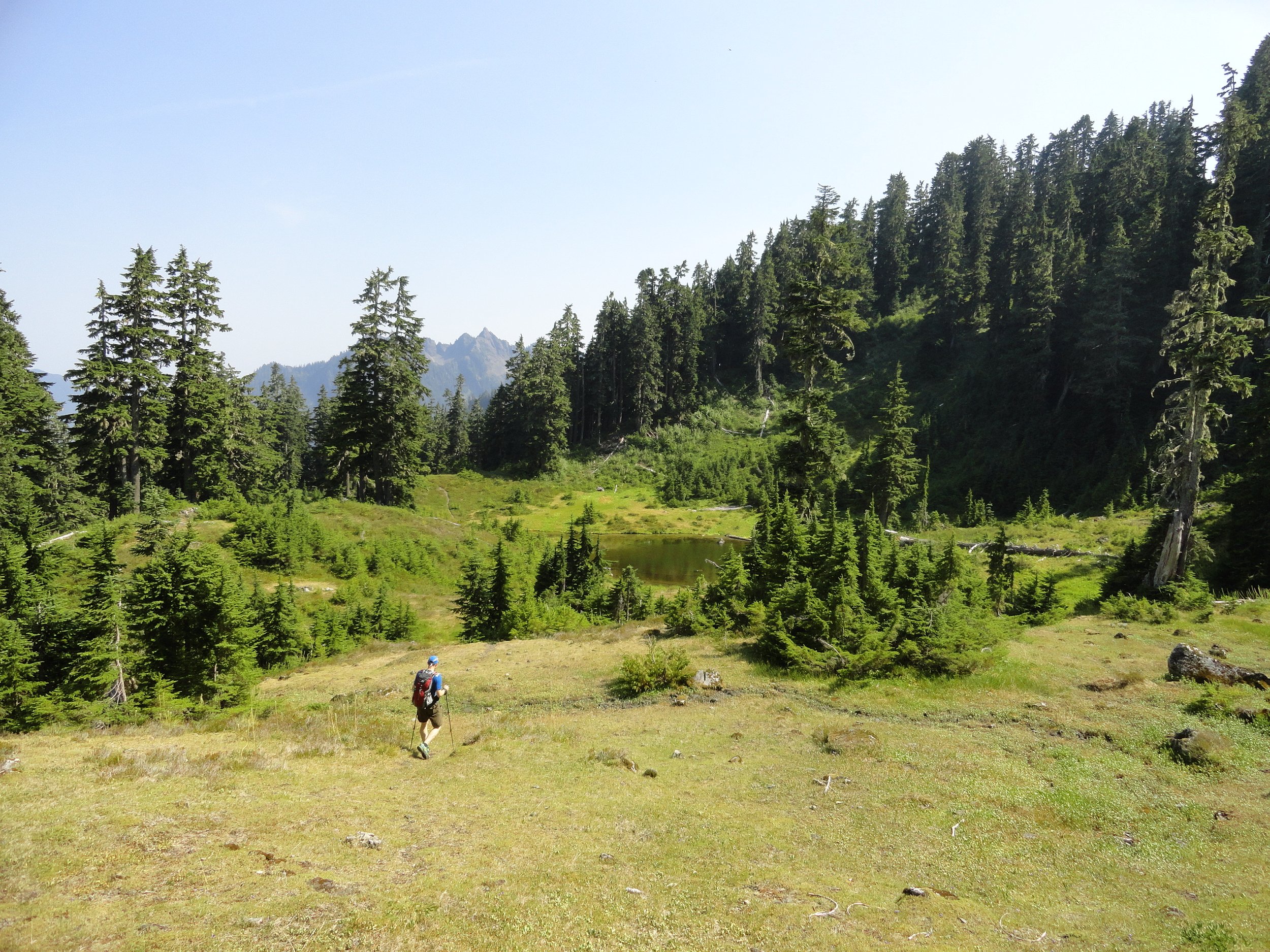
Continue deeper into the wilderness. After crossing a small creek, the trail steeply climbs reaching a small open basin graced with wildflowers in early summer and sparkling tarns providing the headwaters of the South Fork Skokomish River. Now reenter forest and steeply climb once more reaching forested 4,124-foot Sundown Pass. A short descent awaits you next through meadows providing good views of Wynoochee Pass and the Graves Creek drainage. Mount Olympus can be seen in the distance. At 7.8 miles, come to a junction. Left leads to Wynoochee Pass and the North Fork Quinault River.

You want to go right here through a pretty basin reaching Lake Sundown (elev. 3810 feet) in 0.4 mile.
Situated in a semi-open emerald basin on the western flank of Six Ridge, the lake is a pretty sight. A couple of campsites can be found at the old shelter site near the lake’s outlet. To catch the sunset, you’ll need to work your way to the eastern shore to look west across the lake to peaks and ridges beyond. On a warm day the lake’s refreshing waters make for a good dip. Savor the solitude and serenity of this remote backcountry lake. You worked hard to experience it!


More Details
Distance: 16.4 miles roundtrip
Elevation Gain: 3700 feet
High Point: 4125 feet
Difficulty: difficult
Snow free: July—October
Trailhead Pass Needed: None
Notes: FR 2361 closed Oct 1–Apr 30 to protect wildlife. Hike involves two fords safe only in low flow; dogs prohibited at national park boundary. Camping at Lake Sundown and in Olympic National Park requires an Olympic NP wilderness camping permit. No fires above 3500'.
GPS waypoints:
Trailhead: N 47 28.765, W 123 27.125
Lake Sundown: N47 32.170 W123 30.691
Land Agency Contact: Olympic National Forest, Hood Canal Ranger District, Quilcene, (360) 765-2200, http://www.fs.usda.gov/olympic; and Olympic National Park, Wilderness Information Center, (360) 565-3100, www.nps.gov/olym
Recommended Guidebook: Day Hiking Olympic Peninsula 2nd edition (Romano, Mountaineers Books)
Trailhead directions: From Shelton, travel north on US 101 for 7 miles, turning left at milepost 340 onto the Skokomish Valley Road (signed “Skokomish Recreation Area”). Follow for 5.6 miles, bearing right at a V intersection onto Forest Road 23. Continue for 9.3 miles bearing left at Y-junction with FR 2353. Then continue on FR 23, following this good gravel road for 4.3 miles and bearing right onto FR 2361. Then proceed 5.1 miles to trailhead at road’s end.