
Mildred Lakes
Craig Romano is an author of more than twenty hiking guidebooks including the bestselling Day Hiking Olympic Peninsula 2nd Edition (Mountaineers Books), which includes detailed descriptions for 136 hikes throughout the Olympic Peninsula. He is a featured columnist for the Fjord and Explore Hood Canal.
t’s the hardest, nastiest, meanest trail in the Olympics! And that declaration should not be taken lightly, as I have hiked thousands of miles (and written about hundreds of hikes) throughout the Olympic Peninsula. With perhaps only the trail to Lake Constance ranking as just as nasty—you won’t find a more curse-inducing trail than this one. The first time I ever hiked to the Mildred Lakes, I swore to myself that I would never ever do this trail again. I hated it. But alas, I was back on that wretched trail again a few years afterward. And my conclusion was that it’s still the hardest, nastiest, you-have-to-be-crazy-for hiking-this trail in the Olympics! So are you interested in hiking it?
Distance: 9.0 miles roundtrip | Elevation Gain: 2900 feet | High Point: 4100 feet Difficulty Loop: difficult | Snow free: July to October
Trailhead Pass Needed: Northwest Forest Pass or Interagency Pass
GPS waypoints: Trailhead: N47 34.517, W123 15.672 | Upper Lake: N47 33.461 W123 18.021
Hit the Trail
Okay, before hitting this trail, let’s have a chat.
No cheery coating—this is what you’re in for. This trail was never officially built. The trailhead was however. It’s fancy with a picnic table, privy and a view of a stunning waterfall. But don’t let those amenities fool you into thinking the trail is anything special. The trail is only 4.5 miles to the lakes, yet it will take you nearly that many hours to reach them. Why? The actual evaluation difference between the trailhead and the lakes is a mere 1,900 feet. But the real elevation gain is more than 3200 feet with copious ups and downs.
®Craig Romano Photo
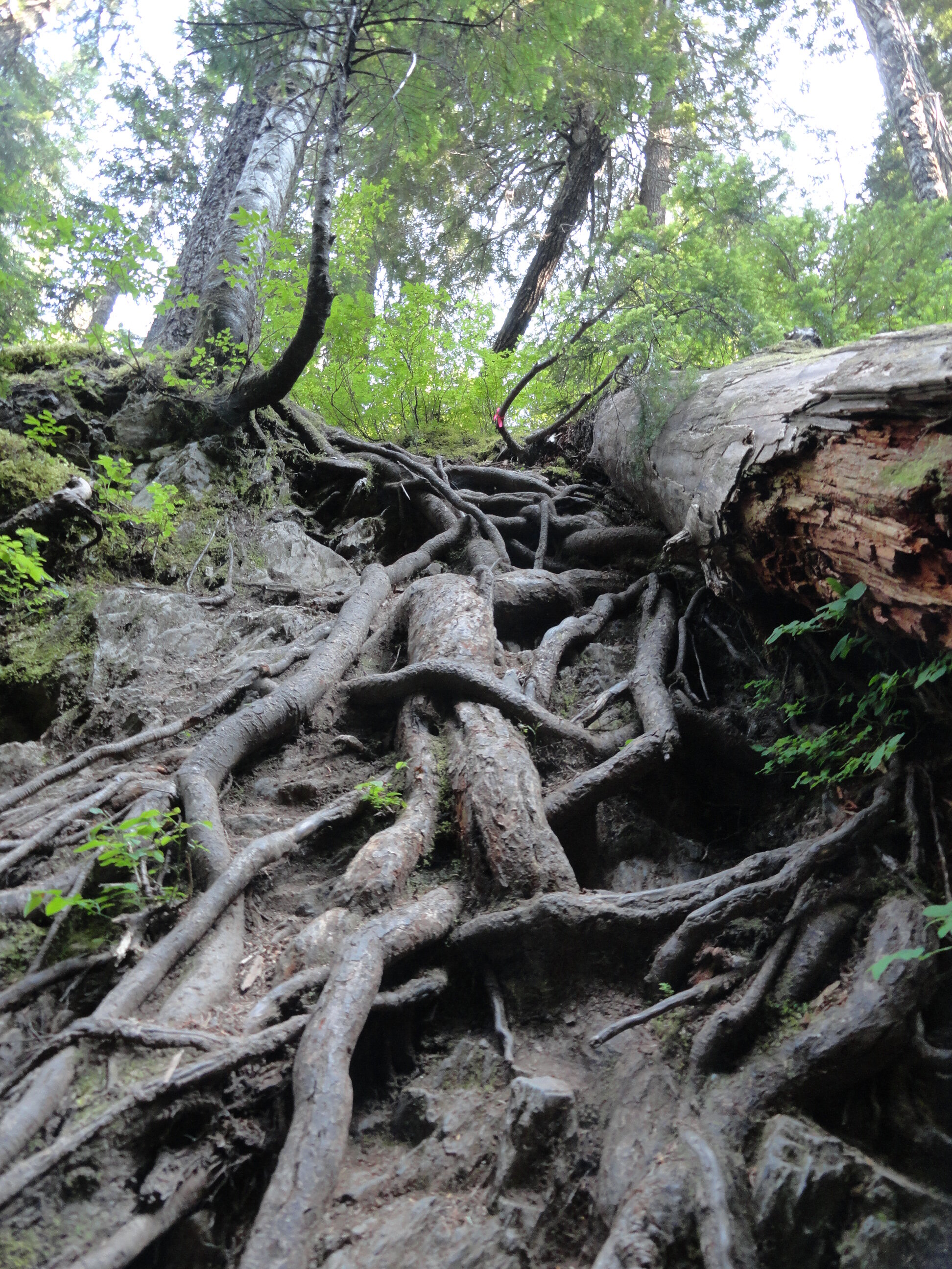
There’s one section of trail that climbs more than 1,000 feet in about a half mile. It is a nasty clamber up roots, rocks and loose gravel. But don’t curse the root—for they’ll be your handholds. There’s another trail section where you have to vertically drop about 25 feet into a tight ravine. And you’ll be using a veggie belay to climb out of it. You will skirt mud, go through mud, and probably be covered in mud upon reaching the lakes.
And if you don’t let out a scream, your knees and toes most certainly will! So why then unless you’re a sheer masochist would anyone want to hike this trail? For one thing, the Mildred Lakes are among the largest backcountry lakes the Olympics. Their setting is quite sublime in a rugged basin surrounded by serrated peaks. You will definitely earn these lakes; as many hikers just aren’t cut out for this grueling journey. That means you’ll see a fraction of the amount of people you’d see at nearby Lena Lake.
And in this age of social distancing, the Mildred Lakes’ brutal approach helps make that directive easier to comply. So if you’re ready to bust your rump, read on!

Hamma Hamma Falls | ®George Stenberg
The Mildred Lakes Trail leaves the roar of the cascading Hamma Hamma River behind and enters the 13,000-acre Mount Skokomish Wilderness. Starting out fairly easy, the path winds through an old cut that has been growing back in pretty nicely. The way then passes a large avalanche chute and enters gorgeous old growth forest. Here what once a decent path now deteriorates into an obstacle course. Around fallen logs, over fallen logs, and straight-up rocky and rooty slopes the trail steeply climbs a 3200-foot ridge. Catch your breath, wipe the sweat from your brow and enjoy a good view of nearby Mount Pershing looming above.

®Craig Romano Photo
The trail then descends from the ridge into a cool forested glen graced by rushing Huckleberry Creek. And yes, there are huckleberries here—lots of ‘em to sweeten this hike a tad come late summer. At the creek come to a questionable log crossing. You can teeter on it to cross the creek. But it’s probably far safer to wade across. Don’t bother drying your feet, because another creek crossing awaits shortly afterward.
The trail now get tougher and a tad bit tricky. It ascends a steep ridge and comes to a tight ravine. Using roots as handholds, drop 25 steep feet into the dank draw before resuming a taxing climb. After clambering over rock, root, and ledge—and gaining 1000 feet in elevation in a little more than a half mile—the insanity ends on a 4100-foot ridge. Now wander along open ledges, enjoying excellent views of Mount Cruiser and the Sawtooth Range. You might be a little dismayed however as there are no lakes in sight. Your punishment isn’t over yet.

®Craig Romano Photo
The trail continues. Drop 250 feet and trudge through marshy mosquito breeding grounds. Make haste through it and finally reach the first of the Mildred Lakes. It’s set in deep old timber with a backdrop of rugged summits. The scene is serene. Scramble over more roots and rocks to the far side of the lake for good fishing spots, resting spots and campsites. Watch resident osprey dive bomb the placid lake.
The other lakes are prettier, so carry on by crossing lower Mildred’s inlet stream and following a rough path through heather meadows for about 0.3 mile to a junction. Here a rudimentary path leads right to middle Mildred Lake. Admire its rocky islands. Upper Mildred, one of the largest backcountry lakes in the Olympics can be reached by continuing on the more defined path for just a couple hundred yards forward. Located in a bowl between Mount Lincoln and Mount Cruiser, the setting is as rugged as the terrain you just hiked across. Quite beautiful too, and hopefully justification for all of the bruises, scratches, and aches and pains you’ll bring back with you to the trailhead.

®Craig Romano Photo
Mildred Lakes Notes

Wilderness rules apply
Land Agency Contact: Olympic National Forest, Hood Canal Ranger District, Quilcene, (360) 765-2200; http://www.fs.usda.gov/olympic
Recommended Map: Green Trails Olympic Mountains East 168S
Recommended Guidebooks: Day Hiking Olympic Peninsula 2nd edition (Romano, Mountaineers Books)
Trailhead directions: From Hoodsport travel north on US 101 north for 13.7 miles turning left at milepost 318 onto FR 25 (Hamma Hamma River Road). Continue for 13.3 miles (the last five miles are gravel and can be rough) to the trailhead.
Trailhead facilities: privy, picnic area
Tips for safe and healthy hiking during the Covid-19 Pandemic
It’s imperative that we do all we can to prohibit a second devastating outbreak of this disease. We can do that by adhering to the following while we enjoy our trails:
Avoid crowded hiking destinations. If you arrive and the parking lot is already full, head to another location
Avoid hiking in large groups outside of your family
Practice Social Distancing while on the trail, giving other hikers lots of room to pass and keeping your distance from them at lakes, summits, etc.
Wear a mask when encountering others on the trail. A buff or bandanna works well.
Pack hand sanitizer
Pack it in pack it out
Don’t be a surface pooper. Learn how to properly poop in the woods by always using privies first if available-or by heading at least 200 feet away from all trails, campsites and water sources and digging a cat hole for your business. Bury your waste and toilet paper
Pack out all pet waste.