
Lena Lakes Hiking Destinations
Craig Romano | Craigromano.com
Gracing the Hamma Hamma Valley are two lakes sharing the name Lena. But aside from the name, they are strikingly different from each other.
The hike to Lower Lena is an easy kid and dog friendly jaunt through old growth forest. The hike to Upper Lena is a grueling and demanding grunt to a stunning high basin within Olympic National Park. Seasoned backpackers take to the upper lake and often set out afterward to scramble surrounding craggy peaks or head out on a rugged high country route. Lower Lena entertains first time hikers and newbie backpackers often testing their gear and skills for the first time. Expect plenty of company at the lower lake and a good chance for solitude at the Upper Lena.
Hit the Trail
Both lakes use the same approach. On a very well-trodden path head off in second-growth forest. The way immediately climbs, but the grade is gentle. Lena Creek can be heard crashing in the distance.
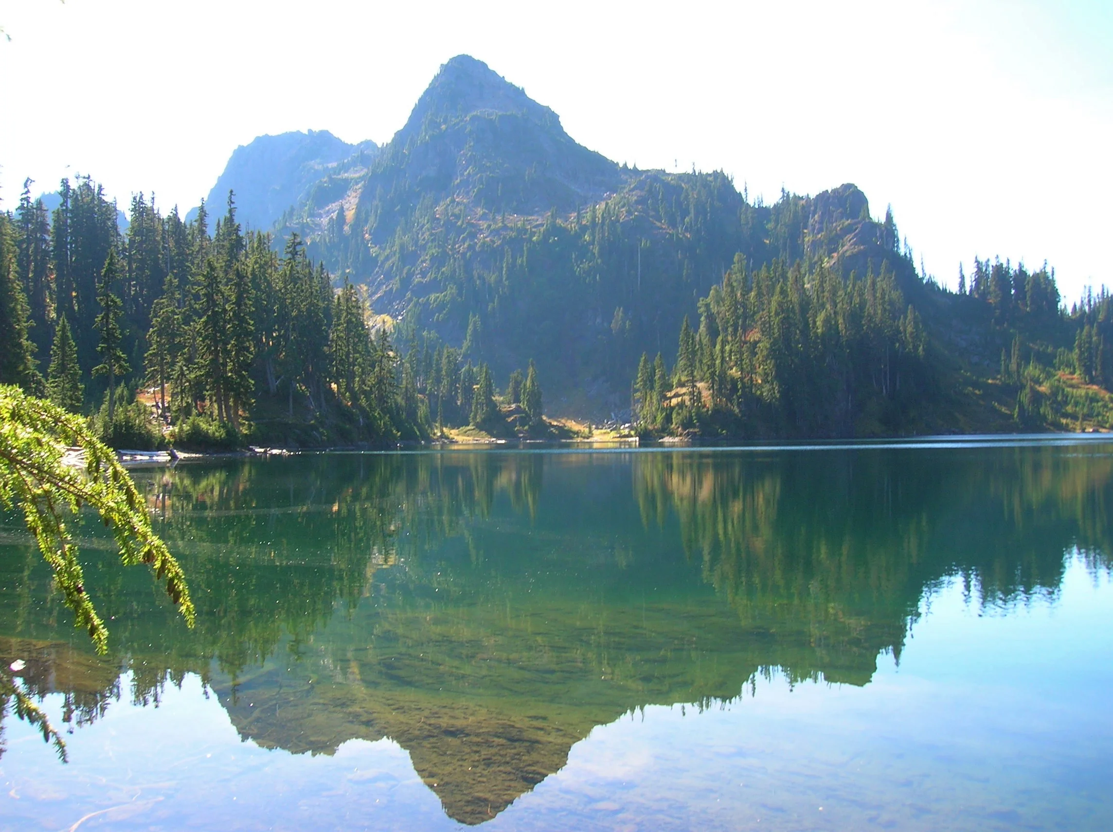
Lena Lake
Continue up the trail and eventually enter groves of beautiful old growth forest. The trail nears Lena Creek and then crosses it on a solid bridge. You might be dismayed however to be standing on a bridge spanning a dry rocky draw. What happened to the creek? It often makes a subterranean passage beneath all of those mossy rocks.
Now continue hiking working your way around and below a ledge. The trail then continues to climb coming to a junction at 3.0 miles. If you’re lower lake bound, bear right and within no time come to an inviting ledge granting a wonderful view of Lena Lake 100 feet below.
To reach the shoreline continue and descend passing busy campsites. You’ll eventually come to a junction with a trail leading back to the trail heading for the upper lake. Head right and reach the shoreline. The trail crosses Lena Creek and continues towards The Brothers—but that’s more of interest to climbers. You’ll figure out in no time that Lena Lake is one of the most popular hikes in the Olympics. Be sure to treat this heavily visited place with care and to practice Leave No Trace ethics.

Upper Lena Lake
If you’re more interested in a wilder setting, skip the trip to Lower Lena and from that first junction, head left. Immediately notice how much lighter the tread is now. Bear left at the next junction and begin following Lena Creek through spectacular primeval forest. At just over 4.0 miles the trail enters Olympic National Park. Dogs are prohibited from this point on—and if you plan to camp at Upper Lena you must have a backcountry permit (issued at Hoodsport Visitor Center and other Olympic National Park ranger stations). Until this point the climbing has been fairly moderate, but that is all about to radically change.
The trail continues alongside Lena Creek heading up an increasingly tighter valley. After crossing a tributary creek on a log bridge the trail gets downright nasty! Prepare yourself for an insanely steep climb up a rocky, rooty, and at times brushy course. It’s arduous and physically taxing, and when soaked by rainfall it can be treacherous. A good set of trekking poles will come in handy. The climbing eases after you carefully negotiate a ledge and clamber up a steep rocky bed of big rocks,
Once again come to and cross Lena Creek, which may be following a subterranean passage here as well.
Continue through open attractive old-growth forest groves. Make one more steep climb before cresting a ridge cradling Upper Lena Lake. Before bolting for the lake, turn around and look back at Mount Rainier in the distance. Now charge for the lake. Enjoy a breathtakingly beautiful backdrop view of 5960-foot Mount Bretherton rising above and reflecting in the lake. Camps (permits required) are along the lake’s eastern shore, and by a short path, on the lake’s western shore.

If you’re up for the day, stay awhile and soak up the beauty. In autumn the surrounding hills colorfully reflect in the lake’s placid waters. Look for critters big and small frolicking in those hills looking for berries. Feel free to help yourself to a handful as well. If you have any energy left consider following a half mile side trail to beautiful Milk Lake set beneath a small glacier on Mount Bretherton. Then rest up and prepare your knees for the brutal and jarring descent back to your vehicle. The beauty and solitude are definitely worth the grind.
Craig Romano
Award winning author and outdoors writer who has authored and co-authored of more than 20 books including Day Hiking Olympic Peninsula 2nd Edition (Mountaineers Books), which features 136 hikes on the Olympic Peninsula. craigromano.com
Lena Lakes Details
Distance:
Lower Lake: 6.0 miles roundtrip; Upper Lake: 14.0 miles roundtrip
Elevation Gain: Lower Lake: 1225 feet; Upper Lake: 4100 feet
High Point: Lower Lake: 1900 feet; Upper Lake: 4600 feet
Difficulty: Lower Lake: moderate; Upper Lake: strenuous
Snow free: Lower Lake: March—Dec; Upper Lake: July—November
Trailhead Pass Needed: Northwest Forest Pass or Interagency
GPS waypoints:
Trailhead: N47 35.984 W123 09.055
Lower Lake: N47 36.994 W123 09.789
Upper Lake: N47 38.068 W123 12.329
Dogs are ok at Lower Lena but prohibited at Upper Lena Lake.
Camping (no fires) at Upper Lake requires National Park Wilderness Camping Permit (contact Olympic National Park, Wilderness Information Center (360) 565-3100)
Land Agency Contact: Olympic National Forest, Hood Canal Ranger District, Quilcene, fs.usda.gov/olympic and Olympic National Park, nps.gov/olym
Recommended Map: Green Trails Olympic Mountains East 168S
Recommended Guidebooks: Day Hiking Olympic Peninsula 2nd edition and Backpacking Washington (Romano, Mountaineers Books)
Trailhead directions: From Hoodsport travel north on US 101 north for 13.7 miles turning left at milepost 318 onto FR 25 (Hamma Hamma River Road). Continue for 7.5 paved miles to the trailhead.
Trailhead facilities: privy